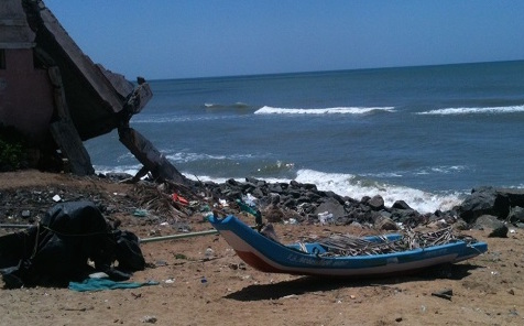
A wrecked house and fishing boat and debris-strewn beach are legacies of the tsunami’s impact on the village of Sulerikattukuppam in Tamil Nadu.
By Sharada Balasubramanian
Climate News Network
CHENNAI, India – It has been over a decade since the devastating tsunami struck southeast Asia, but the horrific memories remain as vivid as ever for people in the coastal villages of the south Indian state of Tamil Nadu.
Now, in the aftermath of the 2004 tsunami and also two cyclones, local people are benefiting from the Indian government’s encouragement of international cooperation in helping vulnerable communities, and have produced a hazard map as a precaution against future disasters.
Vikas Shankar, from the fishing village of Sulerikattukuppam, remembers clearly the moment the tsunami struck.“I was engrossed in playing cricket when I saw water entering the village,” he says. “I thought it was just another day when the sea poured in. Then, suddenly, I saw my mother caught in a whirlpool and realised something was seriously wrong.”
His mother, Tilakavathy, survived the tsunami’s fury, but recalls: “I thought this was really the end of the world.”
Completely destroyed
Amazingly, no one in the village died, but fishermen lost their gear and livelihoods, and many buildings close to the shore were completely destroyed.
The tsunami prompted Tilakavathy and her husband to decide not to send their sons to sea to earn a livelihood.
When Vikas, their youngest son, was old enough, he was sent instead to the local community college, built in 2011 by the state government to provide education and alternative livelihood opportunities for the fishing community.
The local people, recognizing the need for disaster preparedness, are now involved in a program that focuses on developing communication tools for vulnerable communities and raising awareness of other disaster-related issues.
Krishnamurthy Ramasamy, professor of applied geology at the University of Madras, was formerly the principal of the community college. He says: “We realized the need for international collaboration to build a curriculum on disaster management and field-based learning activities.”
Kyoto University in Japan was one of the universities keen to work with him, and two Australian universities, Melbourne and Victoria, also joined in, helping with funds, curriculum development and exchange visits.
“We were taught how and why cyclones and tsunamis happen. It helped us to understand disasters in the first place.”
The college itself fostered community-based preparedness by offering disaster management as an optional subject, and by helping to set up a Local Residents’ Alliance (LRA) in 2013 to mobilize villagers. Most members of this group were parents of students from the college.
Vikas Shankar says: “In the class, we were taught how and why cyclones and tsunamis happen. It helped us to understand disasters in the first place.”
To learn about other people’s best practices, Professor Ramasamy visited communities along the Japanese coast, and there he made a significant discovery. He says: “The first thing I noticed in each village was the hazard map. I thought that we needed this too.”
Back at the college, work on hazard map preparation began, and the first step was students surveying their own villages to understand the geography better.
Teams went from house to house and marked all the huts in the village. They counted the number of people in the house, with details of numbers of women, children, old and disabled people living there. All this information went on the hazard map.
Miwa Abe, from the Centre for Policy Studies at Kumamoto University, Japan, who trained the Indian students, says: “A hazard mapping exercise with local people gives them an opportunity to know their village.
“It is not only about environmental conditions, but also human relationships, social networks, architectural conditions. Usually people do not think about their own area because it is too familiar to them.”
Evacuation routes
The teams also prepared evacuation routes, and, after six months of rigorous work, the students presented the final map to the local people.
Today, as one walks into the village, the first thing to catch the eye is the big blue hazard map board at its entrance. It shows the evacuation routes to be followed during disasters, and also the village’s population distribution − crucial information so that local people will know who to rescue first, and where they live.
The village’s approach is now being used as a case study in efforts to prepare community-based disaster management (CBDM) plans for the entire district, and eventually as a model for the state. The Tamil Nadu government has given land adjacent to the college to establish permanent infrastructure and to provide better facilities for the students.
Rajalakshmi Mahadevan, a fisherman’s daughter, says: “The evacuation map can be read by anyone, even a newcomer. Now we know which house to go to, who to evacuate first, and this has lifted the fear of disaster from local people’s minds.”– Climate News Network
+++++
The U.K.-based Climate News Network is run by four volunteers, all veteran journalists who have covered climate change for many years for leading British newspapers and broadcasters and are now freelancing.
Sharada Balasubramanian, an independent journalist from Tamil Nadu, India, writes on energy, agriculture and the environment.