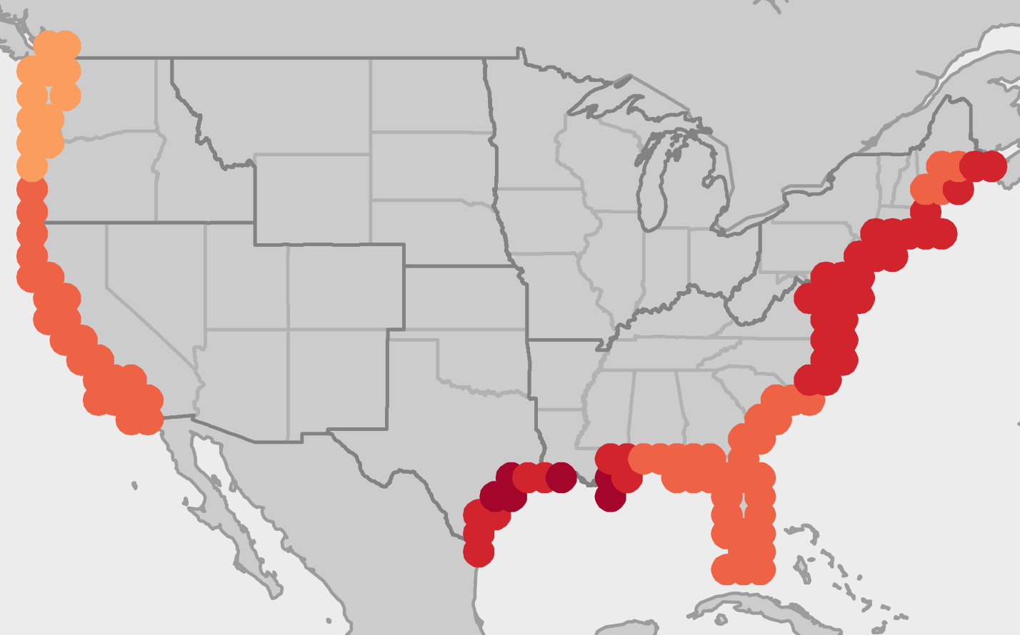
The Texas Gulf Coast is projected to have a greater degree of sea-level rise than most other parts of the U.S. coastline. (Detail of National Climate Assessment map showing sea-level-rise projections. Full graphic below.)
By Bill Dawson
Texas Climate News
As in earlier editions, the latest National Climate Assessment, the fourth, underscores the looming threats that climate disruptions pose to Texas and the state’s acute vulnerability to those already unfolding changes.
The congressionally ordered report, prepared by 13 federal agencies and running to more than 1,600 pages, was the first such summary update since 2014 that outlines what science says about projected climate-change impacts in the U.S.
This edition, released last month, offered stark estimates of the economic toll by century’s end. In a scenario with continuing high emissions of planet-warming greenhouse gases, climate disruptions could shrink the U.S. economy by up to 10 percent. Annual projected costs at that time include $141 billion due to extra heat-related mortality, $118 billion in coastal property damage and $32 billion in infrastructure damage.
The report authors made clear in their introduction that such costs, while not completely avoidable because of human-caused changes already in motion, can be reduced:
Earth’s climate is now changing faster than at any point in the history of modern civilization, primarily as a result of human activities. The impacts of global climate change are already being felt in the United States and are projected to intensify in the future – but the severity of future impacts will depend largely on actions taken to reduce greenhouse gas emissions and to adapt to the changes that will occur.
Each National Climate Assessment builds on the last one – variously repeating, refining and augmenting earlier findings and projections. This one emphasizes the issue’s immediacy. Katharine Hayhoe, a co-author of the Fourth National Climate Assessment and director of Texas Tech University’s Climate Center, summed up that overarching message: “Climate change is happening here and now. It is affecting all of us no matter where we live. And the more climate changes, the more serious and even more dangerous the impacts will become.”
The report does not present state-by-state appraisals, but it includes ample information about and pertinent to Texas, much of it scattered amid many maps and other graphics. What follows is an interpretive selection by Texas Climate News of some key examples.
+++
How hot will it get?
Texas is a famously hot place already. Scientists have been saying for years that manmade climate change will only make conditions hotter still. The new National Climate Assessment does nothing to undercut that message.
As the first pair of maps below shows, the extra heat is projected to be much more severe with continuing high levels of greenhouse pollution from fossil-fuel use. Small consolation as it may be, the four national maps show that parts of the country to the north of Texas are generally expected to record even greater temperature increases than the Lone Star State.
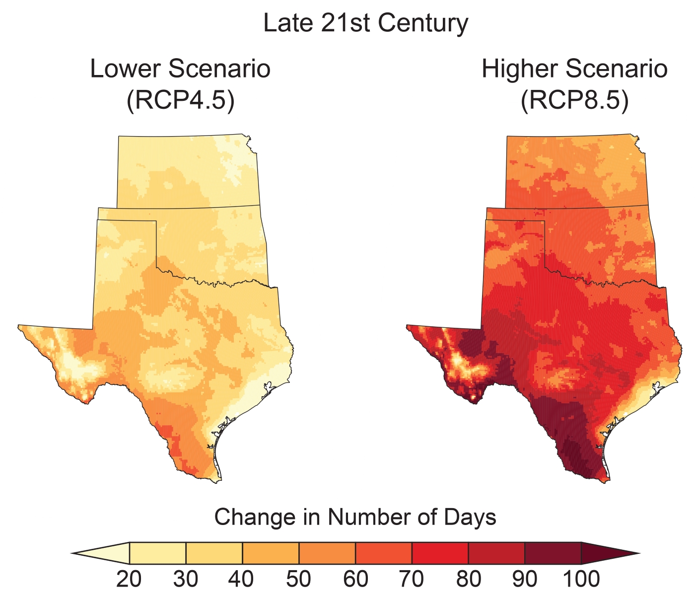
Additional days over 100 degrees, projected for lower-emissions and higher-emission scenarios
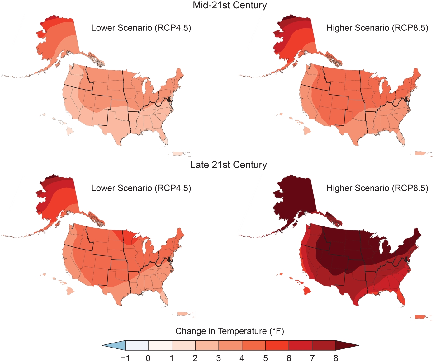
Texas’ projected temperature increases in a nationwide perspective
The report authors made clear that the scientific consensus leaves no doubt for what is behind the warming trend:
The unambiguous long-term warming trend in global average temperature over the last century cannot be explained by natural factors alone. Greenhouse-gas emissions from human activities are the only factors that can account for the observed warming over the last century; there are no credible alternative human or natural explanations supported by the observational evidence. Without human activities, the influence of natural factors alone would actually have had a slight cooling effect on global climate over the last 50 years.
The chapter on the Southern Great Plains region – Texas, Oklahoma and Kansas – gave this appraisal of what lies ahead:
Climate change is expected to lead to an increase in average temperatures as well as frequency, duration, and intensity of extreme heat events and a reduction in extreme cold events. Annual average temperatures in the Southern Great Plains are projected to increase by 3.6 –5.1 degrees F by the mid-21st century and by 4.4 – 8.4 degrees F by the late 21st century, compared to the average for 1976–2005, and are dependent on future scenarios, with higher levels of greenhouse gas emissions leading to greater and faster temperature increases. Extreme heat will become more common. Temperatures similar to the summer of 2011 [the year of Texas’ record-setting heat wave and drought] will become increasingly likely to reoccur, particularly under higher scenarios. By late in the 21st century, if no reductions in emissions take place, the region is projected to experience an additional 30–60 days per year above 100 degrees F than it does now.
“Today,” the authors noted, “the largest uncertainty in projecting future climate conditions is the level of greenhouse-gas emissions going forward.”
They mainly used two emission scenarios in the report, which are reflected in some of the graphics in this article – the lower-emissions scenario (RCP4.5) envisions about 85 percent lower emissions than the higher scenario (RCP8.5) by 2100.
+++
Health impacts of a changing climate
The authors outlined health risks emphasizing already-vulnerable populations:
Higher temperatures, increasing air-quality risks, more frequent and intense extreme weather and climate-related events, increases in coastal flooding, disruption of ecosystem services, and other changes increasingly threaten the health and well-being of the American people, particularly populations that are already vulnerable. Future climate change is expected to further disrupt many areas of life, exacerbating existing challenges and revealing new risks to health and prosperity.
The two graphics below show how Texas is projected to fare, compared to other areas, in terms of two climate-dependent health hazards – higher mortality from higher temperatures and higher levels of ground-level ozone.
Texas’ projected mortality increases due to higher temperatures are comparable with those in many areas and lower than some projections in parts of the Southeast and Midwest.
Levels of ozone, a lung-damaging respiratory hazard that forms in daytime reactions among other air pollutants, vary depending on changing weather conditions and emissions of ozone-forming chemicals. The National Climate Assessment’s projection for Texas showed parts of the state with rising ozone levels due to climate change and other areas with declining levels.
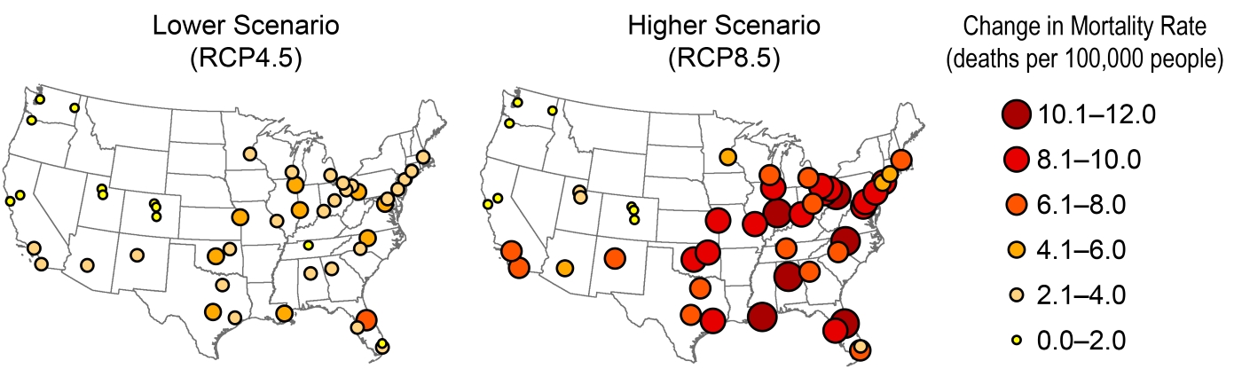
Rising mortality rates projected in lower- and higher-emission scenarios
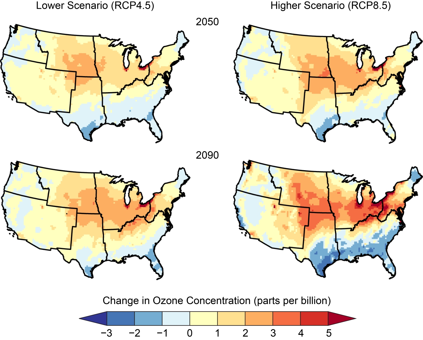
Changes in ground-level ozone concentrations under different emissions scenarios at mid-century and near the century’s end
+++
Rising costs with rising temperatures
The new National Climate Assessment stresses extra economic costs caused by a changing climate. The graphics below illustrate the Texas relevance of three aspects of this broader subject.
The first map shows that Texas is projected by century’s end to be a national leader in new energy expenditures as the climate heats up. Areas of the state with the largest extra energy costs (counties marked in red) correlate with higher projected temperatures in maps above.
The second and third maps below show that Texas is projected to sustain some of the most damaging sea-level rise in the country in both lower- and higher-emission scenarios.
The fourth map below shows military infrastructure deemed to be at risk of climate-change impacts is scattered across much of the state, suggesting the widespread nature of other infrastructure, governmental and private, that is also jeopardized.
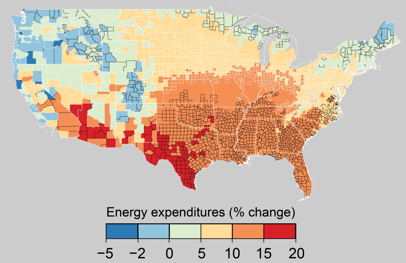
Projected increases in energy costs
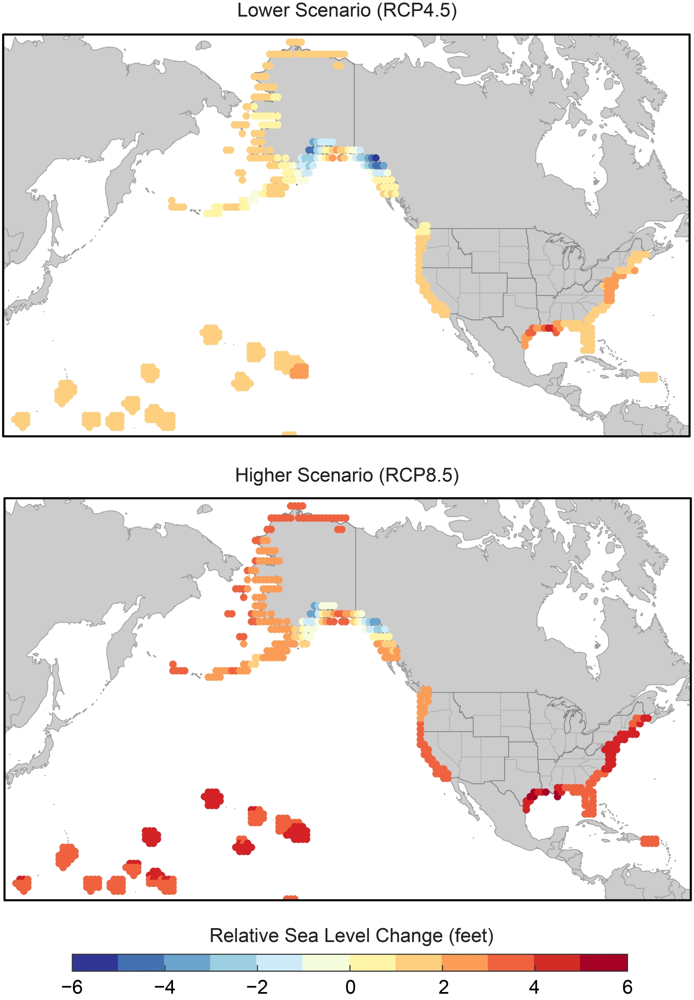
Sea-level rise along the Texas coast is projected to be among the nation’s most damaging
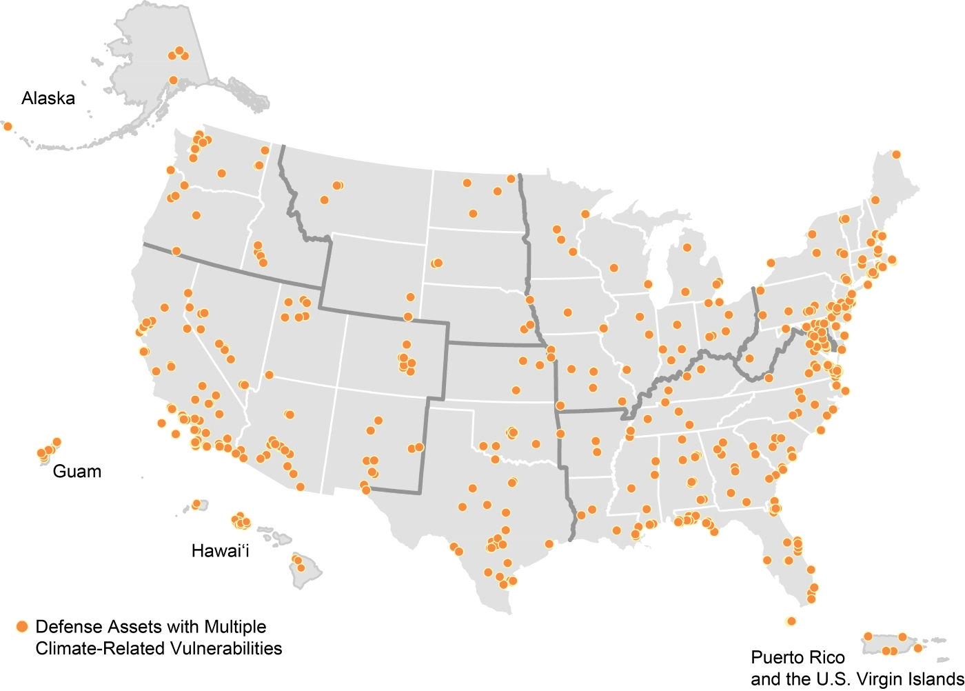
Defense Department infrastructure at risk of climate-change impacts
Oil, natural gas, and electrical infrastructure located along the coasts of the Atlantic Ocean and Gulf of Mexico are at increased risk of damage from rising sea levels and stronger hurricanes; regional disruptions are expected to have national implications.
[…]
Along the Texas coastline, sea levels have risen five to 17 inches over the last 100 years, depending on local topography and subsidence (sinking of land). Sea level rise along the western Gulf of Mexico during the remainder of the 21st century is likely to be greater than the projected global average of one to four feet or more. Such a change, along with the related retreat of the Gulf coastline, will exacerbate risks and impacts from storm surges.
[…]
Relative sea-level rise along the Texas Gulf Coast is twice as large as the global average, and an extreme storm surge in Galveston Bay would threaten much of the U.S. petroleum and natural gas refining capacity.
The authors said projections indicating sea-level rise of 3.3 feet (at the high end of the “very likely” range in their lower-emissions scenario) would more than triple the vulnerability of electricity-producing plants in Texas (with capacity of about 2.8 gigawatts) in a 100-year flood. Sea-level rise of less than 1.6 feet would double the number of refineries vulnerable to flooding in Texas and Louisiana under the report’s lower-emissions scenario.
+++
Contrasting Texas responses in mitigation, adaptation
While the report authors didn’t highlight the difference in explicit terms, an overall review of the National Climate Assessment reveals a contrast in Texas’ approach to the two key aspects of addressing climate change that experts have identified for years.
One is generally called “mitigation” – the wide variety of actions that can be launched to reduce atmosphere-warming greenhouse pollution. The other is generally called “adaptation” – the also large variety of actions that can be undertaken to get ready for climate disruption already occurring and expected due to past and continuing pollution.
As the first map below indicates, the authors identified a smaller number of cities undertaking mitigation actions in Texas, as well as a smaller number of state-level mitigation activities in the state, compared to some other parts of the country including California, the Pacific Northwest and the Northeast.
At least as indicated by the second map below, however, Texas is attracting attention for some of its adaptation strategies, such as its number of desalination plants, regarded as a valuable strategy to prepare for future droughts. Elsewhere in the report, the authors also positively highlighted other adaptation measures in Texas, including several that were launched in response Hurricane Harvey, which struck the state in 2017.
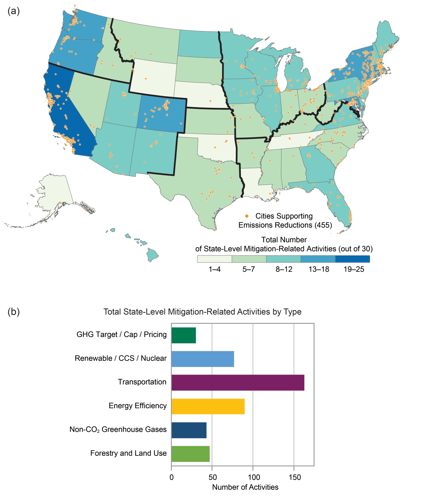
Texas ranks among the states with lower numbers of state-level activities to mitigate climate change – that is, activities undertaken to reduce climate-changing pollution.
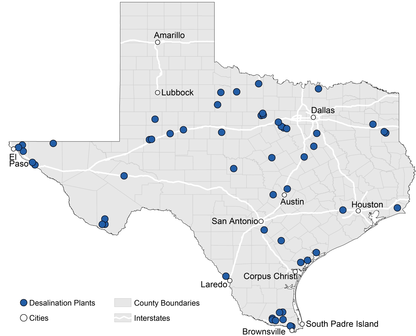
Desalination plants aimed at augmenting drinking-water supplies are scattered across Texas.
While noting some of Texas’ approaches to climate adaptation, the authors also saw a need for many more such actions in their assessment of the situation in the Southern Great Plains region including the state:
Quality of life in the region will be compromised as increasing population, the migration of individuals from rural to urban locations, and a changing climate redistribute demand at the intersection of food consumption, energy production, and water resources. A growing number of adaptation strategies, improved climate services, and early warning decision support systems will more effectively manage the complex regional, national, and transnational issues associated with food, energy, and water.
+++++
Bill Dawson is the founding editor of Texas Climate News. Katharine Hayhoe is a member of TCN’s volunteer Advisory Board.