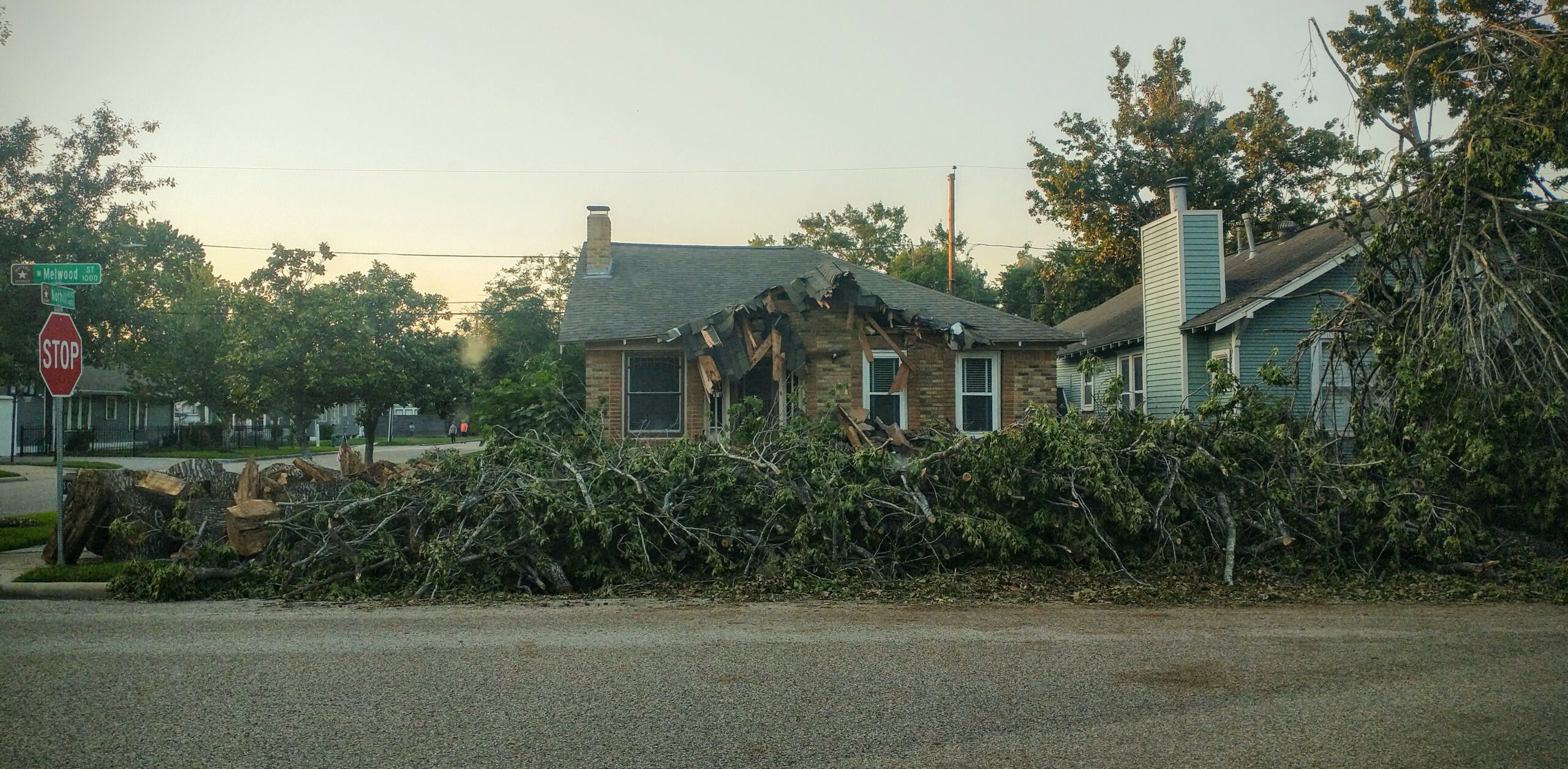
Derecho-caused damage in a neighborhood near downtown Houston. Krist Bender / Texas Climate News
Harris County, heart of the sprawling Houston metro region, sits at the very top of a federal list that ranks U.S. counties according to their cumulative risks from weather and climate disasters.
In the risk-mapping project, the National Oceanic and Atmospheric Administration combines “data about the expected annual losses to individual natural hazards, social vulnerability and community resilience.” On a scale of 0 (the smallest combined risk) to 100 (the greatest), Harris County is the only county out of more than 3,000 across the nation to get a 100 score.
While Harris County’s lonesome perch atop the hazard list might surprise some Houston-area residents, the declaration that they face severe atmospheric hazards on a regular basis will not shock anyone in the city who lived through a string of devastating hurricanes, floods from inland storms, heatwaves and droughts, and dangerously cold winter weather in recent years.
A line of thunderstorms with winds up to 100 mph that crossed the Houston region on May 16, however, introduced a term that was likely not part of many residents’ disaster vocabulary – meteorologists said the storm system’s features, which included two tornadoes, qualified it as what weather experts call a derecho.
More than 900,000 customers of the region’s electricity provider lost power, some for days after the storm had passed and heat-index numbers soared. Eight deaths were attributed to the derecho. Widespread damage included trees downed and damaged across the city, many impaired by previous drought conditions, and downtown streets littered with shards of glass after winds blew out windows in some of the city’s famous office towers.
The derecho renewed calls for the adoption of still resilience measures to help Houston withstand extreme weather events. Especially after Hurricane Harvey brought catastrophic flooding to Houston in 2017, climate scientists’ findings about the ways that climate change is boosting hurricanes’ hazards has been part of that public discussion.
Scientists, however, have generally paid less attention to, and expressed less certainty about, the effects of global warming on derechos, compared to some other weather extremes. But that appears to be changing. Recent research has tied increasing derecho severity to climate change. A couple of new studies are summarized below. But first, some derecho basics.
On a Frequently Asked Questions web page about derechos, the National Weather Service’s Storm Prediction Center provides this basic definition:
A derecho (pronounced similar to “deh-REY-cho” in English) is a widespread, long-lived wind storm associated with a band of rapidly moving showers or thunderstorms variously known as a squall line, bow echo, or quasi-linear convective system. Although a derecho can produce destruction similar to that of a tornado, the damage typically occurs in one direction along a relatively straight swath. As a result, the term “straight-line wind damage” sometimes is used to describe derecho damage.
The UN-sponsored Intergovernmental Panel on Climate Change, the world scientific community’s leading body assessing how fossil-fuel pollution and other human activities are altering the climate, issued its most recent report synthesizing recent research on severe wind storms, including derechos, in 2021.
At that time, the IPCC said scientists had “medium confidence” (about a five-in-10 chance of being correct) that climate change is bringing stronger storms and a longer “storm season” to the United States:
[P]rojections of favorable environments for severe storms (based on convective available potential energy and wind shear indicate medium confidence for more severe storms and a longer convective storm season in the U.S.A., weaker increases extending north and east, and a corresponding increase in autumn and winter tornadic storms.
In the same discussion of several types of severe wind storms, the IPCC said this about tornadoes:
Observational studies have indicated a reduction in the number of tornado days in the U.S.A., but increases in outbreaks with 30 or more tornadoes in one day, the density of tornado clusters, and overall tornado power.
Pre-derecho conditions
The Washington Post published an article after the recent Houston derecho with a detailed answer to the question posed in its headline: “Why was Houston’s deadly thunderstorm so violent?” The two authors, both meteorologists, explained how weather conditions produced the storm and their links to climate change. Those conditions included a “heat dome” south of Texas:
The heat dome — which helped provide fuel for the Texas storms — has produced record warmth in South Florida for days, including a heat index near 115 in Key West on Wednesday, around its highest on record. Scores of other high temperature records have been set in South Florida over the past week.
Stretching across the Gulf of Mexico and Caribbean and into Central America, the heat dome has also been responsible for hundreds of heat records from South America to Mexico, where it has intensified extreme drought and fueled wildfires which have sent smoke into the southern United States.
The warm waters of the Gulf of Mexico, which are running 4 to 5 degrees above normal, probably also contributed to the intensity of storms. The world’s oceans have been record-warm for 13 months, according to the World Meteorological Organization.
Human-caused climate change is intensifying the heat over both land and oceans, increasing the likelihood that it’s record-setting. Climate Central’s Climate Shift Index indicates that it made South Florida’s record heat in recent days at least three to four times as probable.
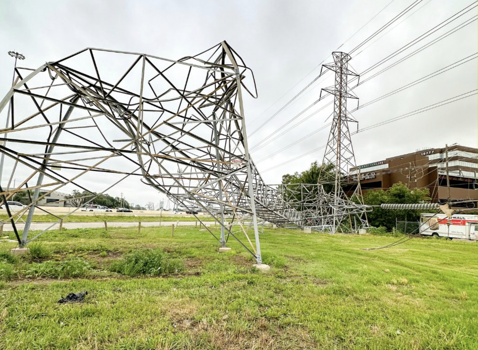
The derecho that swept across the Houston area toppled numerous transmission towers. CenterPoint Energy via X
Recent research
In a study published in the journal Nature last November, a scientist at the National Center for Atmospheric Research in Colorado reported that climate change has been increasing both the frequency and intensity of straight-line winds [SLWs] associated with thunderstorms over recent decades.
The study focused on the central United States, which the study author, Andreas F. Prein, noted is “a global hot spot” for straight-line winds. Prein wrote that in his analysis he “used observations, high-resolution modeling and theoretical considerations to show that SLWs have intensified over the past 40 years.”
While theoretical considerations suggest, for instance, that straight-line winds should intensify by about 7.5 percent for each Celsius degree of climate warming, observed rates actually increased by about 13 percent, he wrote. Simulations also indicated a 3.6-fold to 6-fold increase during the study period of the geographic extent of straight-line winds.
“This study highlights the urgency to incorporate increasing risk from SLWs in current and future climate change adaptation planning to build resiliency against this frequently neglected peril,” Prein concluded.
Another recent study – this one conducted by three researchers at the University of Illinois Urbana Champaign and published by the American Meteorological Society last October – used a different approach to reach a more mixed finding – future derechos might not become more intense because of atmospheric warming but could have a broader scope.
The study analyzed how a 2020 derecho in the Midwestern U.S. – the costliest U.S. thunderstorm event on record, according to federal officials – might be different in a warmer climate around the turn of the century. The researchers assumed a scenario with high emissions of greenhouse gases continuing until then. Computer simulations “suggest that near the end of this century, a similar derecho event may not necessarily have more intense winds but could possibly impact a geographical area 50% to 100% larger,” the researchers concluded.
Their future projections incorporated a “worst-case” emissions scenario that scientists have used in many previous studies to compare the effectiveness of different emission-reducing policies in limiting future climate warming. Some researchers in recent years have questioned the accuracy of the “worst-case” scenario as a predictor of warming in 2100 because assorted measures to reduce emissions have been implemented since the scenario was developed.
Bob Henson, a meteorologist and journalist, contributed to this article. Henson is a Texas Climate News contributing editor.