Flooding at Baton Rouge, La., on Aug. 15. U.S. Coast photo by Petty Officer 1st Class Melissa Leake, posted to Flickr by U.S. Department of State (IIP).
By Bill Dawson
Texas Climate News
National news coverage of the catastrophic flooding that struck large areas of Louisiana recently has diminished as floodwaters subsided and rescue operations gave way to recovery efforts.
Cautionary appraisals of the Louisiana deluge’s significance continue to be pertinent, however, for Texans and others living near the Gulf. The latest reminders: A couple of low pressure areas – one off the Southeast Texas coast and another near the tip of Florida – attracted increasingly concerned attention over the weekend.
Inspired by the then-unfolding Louisiana disaster after six locations received more than two feet of rain, Katharine Hayhoe, a climate scientist at Texas Tech University, sketched out the basics about Gulf storms’ links to climate change in a Facebook post:
Flood is a natural risk in Louisiana; but today, climate change is exacerbating that natural risk, making heavy downpours stronger and more frequent.
What’s the connection? As the atmosphere warms, so does the ocean. Evaporation speeds up, making more water available for a storm to pick up and dump as it sweeps through.
And this isn’t just a future risk: the Southeast has seen a 27 percent increase in the amount of precipitation falling in the heaviest events from 1958-2014, and nine of the top 10 years for extreme one-day precipitation events have occurred since 1990.
Angela Fritz, an atmospheric scientist and deputy weather editor of the Washington Post, assessed the Louisiana downpour:
The disaster was caused by two weather-related features — extreme humidity and near-stationary low pressure that hovered over the Gulf Coast for days.
Precipitable water — a measure of how much moisture is in the air over a certain location — was off the charts. Day after day, weather balloons relayed precipitable-water data that came close to or exceeded any other weather event on record in the region. On Friday morning, the precipitable-water reading was 2.8 inches.
“Obviously we are in record territory,” the National Weather Service wrote.
Journalist Andrew Freedman, Mashable’s science editor, wrote on that site that “a near-record warm Gulf of Mexico helped add water vapor to the air, with bathtub-like water temperatures near 90 degrees Fahrenheit in parts of the Gulf.”
All in all, Freedman noted, the Louisiana flooding resulted from “a bizarre confluence of weather events that are becoming suspiciously more common as the planet’s climate continues to warm.”
A debate among meteorologists over whether the storm should have been formally classified as “tropical” – the National Weather Service may seem arcane to non-experts, he added. “but settling it may be important if global warming helps spawn more hybrid storm systems that feed off of warmer-than-average waters and take on tropical characteristics even when they are over land.”
Texans shouldn’t rest easy with the hope that non-“tropical” storms like the one that devastated large parts of Louisiana this month are unlikely to hit Texas thanks to some feature of geography or oceanography.
John Nielsen-Gammon, the Texas state climatologist and atmospheric sciences faculty member at Texas A&M University, told Texas Climate News by email:
Texas experienced something meteorologically similar to this back in July 2002 in the San Antonio area. So there’s nothing about the geography or oceanography preventing that sort of event here. Peak rainfall amounts in the Louisiana storm were close to 50 percent larger than what happened in July 2002, when water rushed through the Canyon Dam spillway [on the Guadalupe River in the Texas Hill Country]. To think about the Louisiana flood in Texas, imagine the July 2002 flood, except with up to 50 percent larger peak totals and 20-inch rain amounts stretching from San Antonio to Austin to Temple to Waco.
The 2002 flooding in Central Texas was bad enough as it was, with rain totals for July 1-8 ranging from 15 inches in San Antonio to 31 inches at a Kerr County, west of Austin; 10 deaths; damage to 48,000 homes and $250 million in losses, according to a National Weather Service report.
Nielsen-Gammon also commented on the state of “attribution analyses” – studies that calculate whether human-caused atmospheric warming was a factor in a particular storm and to what extent it affected the severity.
There hasn’t been much climate change attribution work on week-long rain events, but there’s a clear signal of climate change in 1-2-day rainfall events, both historically and in future projections. We don’t know at this point whether or even if weather systems like the one that flooded Louisiana will become more or less common, but given a weather system like that one, the amount of water vapor it ingests and converts to rain is thought to be increasing. The trend estimated from climate models for extreme amounts of atmospheric water vapor content (known as “precipitable water”) is 3 percent per decade. And the amount of water vapor this time was definitely extreme.
Earlier this year, the National Academies of Science, Engineering and Medicine published a comprehensive assessment of the current state of the science underlying attribution analyses – “Attribution of Extreme Weather Events in the Context of Climate Change.”
The committee of expert authors concluded:
The ability to understand and explain extreme events in the context of climate change has developed very rapidly over the past decade. In the past, a typical climate scientist’s response to questions about climate change’s role in any given extreme weather event was, “We cannot attribute any single event to climate change.” The science has advanced to the point that this is no longer true as an unqualified blanket statement. In many cases, it is now often possible to make and defend quantitative statements about the extent to which human-induced climate change (or another causal factor, such as a specific mode of natural variability) has influenced either the magnitude or the probability of occurrence of specific types of events or event classes. The science behind such statements has advanced a great deal in recent years and is still evolving rapidly.
+++
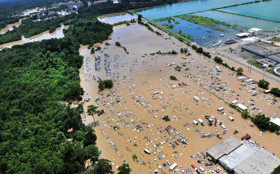
Louisiana flooding, August 2016
- Red Cross: “Likely the worst natural disaster in the United States since 2012’s Superstorm Sandy”
- At least 13 deaths
- 120,000 households registered for emergency assistance by late last week
- Baton Rouge Area Chamber: Residential damage could total more than 145,000 homes worth more than $30 billion across nine parishes (15 percent covered by flood insurance)
- Rainfall: More than 31 inches in one location in Livingston Parish in 15 hours; 32 straight hours of rain (Aug. 11-13) at the Baton Rouge airport
+++++
Bill Dawson is the founder and editor of Texas Climate News.
Katharine Hayhoe and John Nielsen-Gammon are members of the Texas Climate News Advisory Board. The volunteer members have no authority over TCN’s editorial decisions. Nielsen-Gammon serves on the Advisory Board strictly in his capacity as a faculty member at Texas A&M.